So, what if the Earth is
round?
NOTE: This section has more advanced
material; it can be eliminated or
skipped without loss of continuity....
|
How
do we know where we are on the Earth? The Earth is round and so far we
have only dealt with maps representing two dimensions.
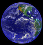
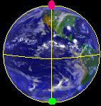
Take a look at the picture of the earth. We can identify it as
being a part of a sphere, we can notice that it has a top and bottom, a
side
that you can see and a side that you cannot see. How can we
clearly identify every point on this spherical surface?
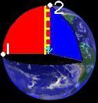
In the picture to the left, we can see a ladder running down the center
of the sphere,
from the top to the bottom along the axis of rotation of the earth,
with a stick figure on on it at a point
exactly half way between the top and the bottom, looking perpendicular
(at a right angle) to the ladder, towards point one, on the surface of
the earth, to the stick
figure's left. We will call this point the
origin, the exact place that all other points will be defined in
relation to in our coordinate system, the method by which we will
define all points on the globe. If the ladder was to
spin
around in a circle, a full 360 degrees of rotation, without the stick
figure changing the angle between its eyes and the ladder, all of the
points traced out by the stick figure's eyes form a circle that we will
call the
equator. If we were to cut the globe
along the equator, we would be left with two identical half spheres,
save for orientation (round side or flat side pointing up). We will
call the top half of the sphere the Northern Hemisphere and the bottom
half of the sphere the Southern Hemisphere.
Now that the ladder has completed its rotation of 360 degrees, the
stick figure will be once again, looking at the origin. If it was
to
want to see the top of the sphere, at point two, it would have to tilt
its head
back 90 degrees, with its head looking directly up the ladder.
Similarly, if it wanted to see the bottom of the globe,
that would require tilting its head 90 degrees down, until looking
along the axis of the ladder. The semicircle that the stick
figure traces out between the north and south poles that crosses the
origin is called the prime meridian.
Now, let's place a compass rose at the original point at which the
stick figure was looking, at the origin, on the surface of the
sphere. North points towards the Northern
Hemisphere, South, towards the Southern Hemisphere, East towards the
right, and west points towards the left. Now, we will define the
location of the origin as being at 0 degrees
north, 0 degrees west (or, similarly, 0 deg. South, 0 deg. East).
If we were to want to look at the extreme top of the
sphere, without rotating at all, we would tilt our heads ninety degrees
North. Therefore, the location of the Northernmost point on the
globe is 90 N. To see the extreme bottom of the sphere, we would tilt
our heads
ninety degrees South, so the Southernmost point on the globe is located
at 90 S. Looking at the origin once again, in
order
to see the point directly behind us, we could either rotate 180
degrees East or 180 degrees West. So the point directly behind us
could be addressed by 0 North, 180 West, or 0 South, 180 West, or 0
North 180 East. There are many ways that we can define each
point, each just as good as the next! Standard convention has
longitude as being measured to the West, with a negative sign sometimes
used to denote movement East. Latitude generally appears in
degrees
North or South. We will soon see why it is crucial to keep our
signs organized.
But first, here's a good way to remember the names latitude and
longitude with
their corresponding lines on a globe. On a globe, lines of
latitude and longitude are generally marked ten or five degrees apart,
respectively. If our stick figure, still on the spinning ladder
in the middle of globe wanted to see a point at a latitude other than 0
degrees, without rotating his head, he would have to climb up or down
on the ladder and then spin to the correct longitude. So when the
stick figure changes its position on the ladder, it can trace out a new line
of latitude. If we look
at the length of the lines of latitude and longitude, we can see that
the lines of longitude always wrap all of the way around the earth
through the North and South poles, each having the circumference of the
earth. Lines of latitude, on the other hand, are circles that
vary in radius between that of the earth, at the equator, and zero, at
the poles. So remember, lines of longitude
are always long.
|
|
|
Now that we can describe where exactly any
point on the
surface of a
sphere is, let's investigate how we can determine the distance between
any two points on a sphere.
If we are given any two points on a sphere, we can connect them with an
arc, a part of a circle. We will call the circle containing this arc a
Great circle. There exists a Great circle for every set of points on a
sphere and each has the same circumference, that of the sphere. We know
that the circumference of a circle is equal to (2r)pi. Since an arc is
part of a circle, the length of an arc is equal to the a ratio
corresponding to how much of a circle the arc completes, which is equal
to the number of degrees of the arc divided by the number of degrees in
a circle, multiplied by the circumference of a circle of that radius.
Length of an arc with n degrees and radius r =
(2r)pi * (# degrees in the arc/360)
Let's say that we want to determine the distance along the Earth's
surface between the North Pole (90 N, gray dot) and the South Pole (90
S, green dot). How far must we travel?
Click
Here
for the Solution
Click
Here for Detailed Hints
That wasn't too difficult, was it? Now we can see that any two
points are connected by a great sphere, and that determining the
distance between the two points is a matter of figuring out how many
degrees along that great circle there are between those two
points. This wasn't too hard when the two points only differed in
displacement in one direction - in the example above, the longitudes
were the same. But how do we determine the number of degrees that
separate the points in the great circle when they differ in location by
both latitude and longitude, in other words, when the great circle is
parallel to neither the equator nor the prime meridian?
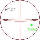
Determine the distance between Tananarive, Madagascar located at 18 S
47 E, and New York City, New York, USA,
located at 40 N 73 W.
Click
Here
for the Solution
Click
Here for Detailed Hints
|
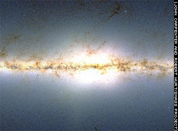 |
Now you can get from state to state and from hemisphere to hemisphere
using the same technique. Let's start thinking much, much BIGGER. Let's
find out how to get around the Milky Way Galaxy. We might assume a
system has been devised that incorporates a:
- Coordinate System
- Origin
- Scale Length
This system is referred to as Galactic Coordinates, but there is a
surprise in store for us now!
Learn
about galactic navigation. |